
Export Map to PDF
Users can download a section of the map as a PDF. This tool can be used to print out any details from the project. Once the ‘Export Map' button is clicked, a menu will be displayed along with a rectangle on the map. The rectangle, which indicates the area on the map to be exported, can be moved.
Depending on whether an A3 or A4 format is selected, the menu will appear as follows:
| Menu A4 | Menu A3 (Default) |
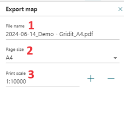 |
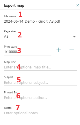 |
Options
| Option | Description |
| 1. File name | The name of the file that will be downloaded when generate is clicked. |
| 2. Page Size | A dropdown menu to select the desired page size. |
| 3. Print Scale | The print scale is used to set the scale for the PDF. Changing the value of the scale will change the size of the rectangle on the map. |
| 4. Map Title (A3) | Add an optional chart title. |
| 5. Subject (A3) | Add a subject (optional). |
| 6. Printed By (A3) | Displays the name of who creates the map in the PDF. |
| 7. Notes (A3) | A place to add any additional notes. |