# Access Data via WFS & WMS APIs
If needed you can display data from GRID**it** in another (external) application.
# WFS & WMS (external applications)
You can view layers that are stored in GRID*it* in other systems (e.g. QGIS) using the WMS and WFS APIs.
When using WMS & WFS to view data in another system, layer level access control cannot be enforced.
External mapping tools & applications can access data via standard interfaces from [Open Spatial Consortium](https://en.wikipedia.org/wiki/Open_Geospatial_Consortium "External link: Open Spatial Consortium (opens new window)").
- WFS (Web Feature Service)
- WMS (Web Map Service)
Each application needs to be configured differently. All applications need to configure the endpoint and the API key.
## Information needed (from administrator)
---
#### API endpoint
---
Each project in GRId*it* has its own endpoint. Your project/organization administrator can provide it and it has this format
| **Protocol** | **Endpoint** |
| **WFS** | example: [https://api.gridit.nl/api/projects/4928f988-8711-4371-b61b-af6b1834c406/WFS](https://api.gridit.nl/api/projects/4928f988-8711-4371-b61b-af6b1834c406/WFS "Example only") |
| **WMS** | example: [https://api.gridit.nl/api/projects/4928f988-8711-4371-b61b-af6b1834c406/WMS](https://api.gridit.nl/api/projects/4928f988-8711-4371-b61b-af6b1834c406/WMS "Example only") |
#### API key (for security)
---
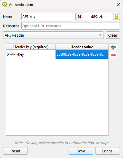
Each user has an API key that can be provided by the project/organization administrator. The API key grants the same access rights as the user.
The API key must be provided as part of the http attributes
| **Attribute** | **Value** |
| X-API-Key | API Key (eg: 8c898c89-8c89-8c89-8c89-8c898c898c89) |
```
let url = 'https://api.gridit.web/api/projects/B1C9AE8D-15ED-454C-A91D-CA48C310CE74/WFS?service=wfs&version=2.0.0&request=GetFeature& typeNames=namespace:featuretype';
const response = await fetch( url, {
method: "GET",
headers: {
"X-API-Key": "8c898c89-8c89-8c89-8c89-8c898c898c89",
},
});
```
##### Example in QGIS:
[](https://wiki.app.gridit.nl/uploads/images/gallery/2026-02/qgis-authentication.png)